Drones document widespread damage and devastation across Northern Bahamas
As the death toll continues to climb in the aftermath of Hurricane Dorian’s September 1 landfall on the Abaco Islands in The Bahamas, professional all-hazards and emergency management teams from the private and public sectors have come together to use aerial drones, combined with cutting-edge rapid mapping technology, to assess damage and offer situational awareness to local Bahamian government officials.
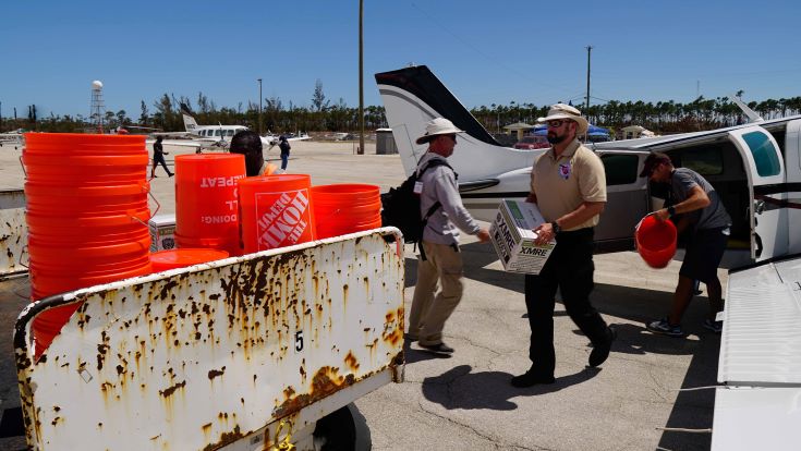
Steve Hynes, Deputy Incident Commander for the Southeast Florida Region 7 all-hazards incident management team, unloads a case of ready to eat meals from a recently arrived aeroplane transporting emergency supplies from West Palm Beach, Florida in the aftermath of Hurricane Dorian. Credit: AIRT
Members of the Airborne international response team (AIRT), a Miami-based non-profit organisation that provides unmanned aircraft system (UAS) capabilities for disaster response, joined members of the Southeast Florida region 7 all-hazards incident management team (SEFL-R7 AHIMT), a professional all-hazards disaster and emergency management team, to form a joint-reconnaissance team to survey damage across the hardest hit areas of the Grand Bahama and the Abaco Islands in the Northern Bahamas.
Operating out of Palm Beach International Airport, the team was able to secure private air transportation to the various islands it visited. Starting in Nassau, the team witnessed the escalating response to the disaster, which included the deployment of some US-based urban search and rescue (USAR) teams aboard US military aircraft, as well as a number of other non-profit groups rushing in to provide much needed assistance.
After co-ordinating with the Bahamian Government, the team proceeded to Freeport where it helped to unload essential supplies, including a school bus filled with newly arrived cases of water, tarpaulins and general supplies for the relief effort. The team then departed to conduct damage assessment operations with aerial drones at the University of The Bahamas – Northern Campus, and nearby neighbourhoods that were hit hardest by Dorian’s fury.
“We saw first-hand the damage that this hurricane leveled upon the Bahamas,” said Nigel Baker, Team Co-ordinator and Incident Commander of SEFL-R7 AHIMT. “The combination of massive storm surge and fierce Category 5 winds was more than most structures could bear, no matter what code they were built under.”
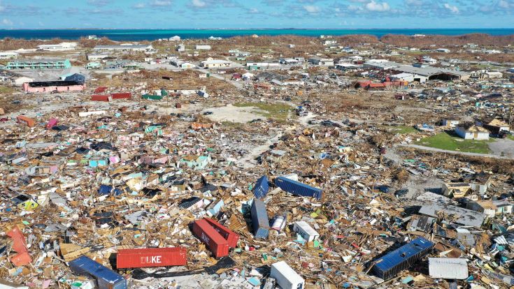
Drone imagery shows brightly coloured homes and shipping containers strewn across the landscape after the fury of Hurricane Dorian’s landfall in the Abaco Islands. Credit: AIRT
At its peak, Dorian’s sustained winds were marked at 185 miles-per-hour, gusting up to 220mph, according to the National Hurricane Center in Miami. The storm surge over some parts of The Bahamas is projected to have been higher than 20 feet, according to local Bahamian officials.
The recon team’s drones were manned with high-resolution camera systems, which helped to map disaster scenes in new ways never before imaginable.
“The debris field at Marsh Harbor was unlike anything I have ever seen,” according to Christopher Todd, Executive Director at AIRT. “By combining the drone with the latest rapid mapping technology, we were able to produce a highly accurate and incredibly detailed digital map of the hardest hit areas of Marsh Harbor and other the towns.”
Todd says this type of solution will soon be in use by SAR teams around the world when responding to disasters like Dorian.
“Beyond just search and rescue and damage assessment missions, these types of systems will help us provide a better understanding of what exactly happened, why it happened, and how it might be prevented from happening again in the future,” according to Todd.
“This new technology is quickly providing new capabilities for emergency managers,” offers Baker. “More detailed information coming in quicker than ever before will allow us to make better decisions that will ultimately help save more lives.”
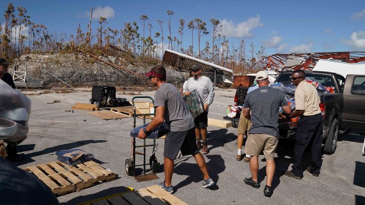
Nigel Baker, Incident Commander for the Southeast Florida Region 7 all-hazards incident management team, helps local residents stack recently arrived emergency supplies in the aftermath of Hurricane Dorian. Credit: AIRT
For now, the team will continue to provide requested support to The Bahamas as its capabilities and authority allow. However, the 2019 hurricane season is not over – danger is lurking as more tropical systems taunt the Caribbean and US East Coast.
“We need to remain vigilant and ready to respond to the next big storm,” says Baker. “We’ll take what we have learned in The Bahamas, continue training, and put this new technology to good use once again when it is most needed.”