Testing drones for search & rescue in Norway's extreme conditions
Drones became front-page news for specialist operators, such as the police in Belgium, the fire service in the Netherlands and even during the terrorist attacks in Paris. And there is no doubt that the emergency services will use commercial drones even more during 2016, says Simon Wigmore.
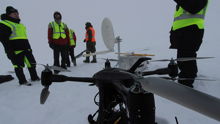
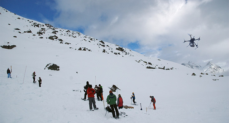
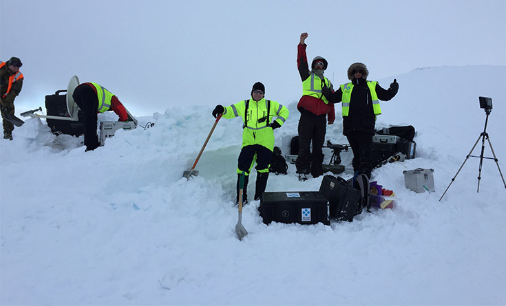
With the cost of helicopters proving increasingly expensive, a drone was used for the first time in a search and rescue operation in Norway. The cold winds were pounding at 20 metres per second, producing a wind chill of -15 degrees Celsius in three metres of snow, and the exercise in Bykle Setesdal was a major undertaking. More than 250 people from the police, fire department, International Red Cross, army and air force took part on slopes 15 kilometres from the nearest road using the Altura Zenith unmanned aerial system (UAS) with dual-sensor camera.
“Sometimes, the weather is so bad here that we cannot use helicopters,” said Ingrid Tronnes Maehre, the deputy chief of staff, Agder Police district in Bykle Setesdal. “We wanted to test whether it is possible to use a drone instead. We wanted to find out what benefit we can get using drones in a rescue scenario and whether drones can help us locate missing or injured people faster,” she said.
The news was positive. According to Maehre, there are very few reports written about using drones for search and rescue. “I tried to find reports of the use of drones during rescue operations, both nationally and internationally. I could not find any, but the drones performed well,” she said.
The Aultura Zenith system provided an aerial overview with optical and thermal cameras and transmitted images to on-site leaders, base camp and police command using mobile networks.
UAS pilot Yannic van Moerkerk had to master the rough winds and poor visibility, but the drone often flew itself. The pilot switched between optical and thermal view, which was an easy victory for the dual-sensor camera.
The video transmission could be viewed anywhere on earth within seconds of capturing it using 4G, 3G and even EDGE technology. When switched to satellite communications, everything was received in an intuitive web interface, allowing the emergency services teams to watch simultaneously.
Elsewhere, the local Belgium police MidLim announced that they would use a new UAS to complement their operations in the Linburg province for monitoring traffic and for crowd control.
A police spokesman leading the innovative new project in the Limburg area, explained that the UAS is multi-functional, and it can be used for maintaining public order, aerial photography and searching for missing persons. The drone they use is essentially equipped with a livestream video connection and a thermal camera. The decision to buy at least one system came after a successful two-year trial.
Three drones were also used to monitor traffic and provide real-time information at the Concert at Sea in Zeeland. The Dutch government used the Zenith ATX 8 to monitor the traffic leading to and from the festival, covering an area of 30 square kilometres.
They were deployed to get a better grasp on traffic jams during a busy festival, which attracted more than 80,000 people. The UAS provided assistance, especially on highways where there was extra traffic due to the festival. Coordinators used a livestream camera connection to redirect traffic along a faster route.
On the eve of the security exhibition, Milipol Paris 2015 last November, Aerialtronics revealed a series of drone sensors for the emergency, health, safety and security industries, which included some of the first nuclear radiation and hazardous chemical detectors on the commercial market. There are now gas monitors and nuclear radiation sensors to add to the advanced thermal and day-vision cameras.
Robin van de Putte, founder and Head of Product Strategy at Aerialtronics, said: “The Zenith UAS, with more than 16 compatible sensors, has the widest compatible payload range on the market. Extending our payload range with the VOC monitor and nuclear radiation detection sensors increases the potential of our system for a number of users including the emergency services.”
Drone autonomy moved to the next level recently with the development of a smart dual camera that packs massive onboard processing power with both digital daylight and thermal camera sensors, which may prove invaluable in search and rescue or emergency operations.
This is a giant step forward in onboard data analysis and processing with drones. The camera can process both raw data streams from the day-night data, allowing the UAS to be used more effectively in a multitude of onboard computing tasks from object detection and recognition to path planning for police, fire and security services.
Jan Wouter Kruyt, Head of R&D at Aerialtronics, said: “We have been developing dual cameras that allow users to switch between daylight and thermal video streams for some time. We have gone a step further by integrating a daylight and digital thermal camera with NVIDIA’s Tegra K1 chip. No one else offers this powerful data combination. Eventually, we will be connecting this to the flight computer and then the whole drone will become smart enough to respond to what it is seeing.”
The technology has great potential. Businesses already use aerial data from UAS to inspect anything from mobile communication towers, to electric pylons, bridges and oilfield pipelines. And there’s more to come.
“This is a major step forward in the level of autonomy for drones,” Kruyt said. “Now you can pre-programme a drone and it will fly on a path you set for it. But if you integrate machine vision on an embedded chipset, you create something more intelligent because it can identify what is around it. If you want to fly around a house or building on fire all you do is press a button. The Altura Zenith will go out with the camera, see what it needs to do, perform a routine inspection and design its own mission based on what it sees. It verifies if it has completed its mission before returning to base.” Great potential indeed.
Simon Wigmore, 12/01/2016